 AP/John Locher
World News Desk
Learn the why behind the headlines.
Subscribe to the Real Truth for FREE news and analysis.
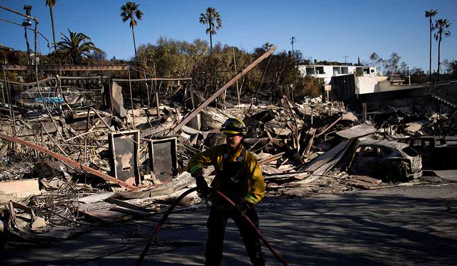
Subscribe NowLOS ANGELES (AP) – Fires tearing through the Los Angeles area have killed at least 24 people, displaced thousands of others and destroyed more than 12,000 structures in what might be the most expensive conflagrations in the nation’s history.
The blazes started last Tuesday, fueled by fierce Santa Ana winds that forecasters expect to kick back up through at least midweek. Cal Fire reported that the Palisades, Eaton, Kenneth and Hurst fires have consumed about 62 square miles.
The Palisades Fire, along the coast, has been blamed for eight deaths, while the Eaton Fire further inland has been blamed for 16 others, the LA County medical examiner’s office said. At least 23 people are missing, and authorities said that number is expected to rise.
Investigators are still trying to determine what sparked the fires. They could be the nation’s costliest ever. Government agencies have not provided preliminary damage estimates yet, but AccuWeather, a company that provides data on weather and its impact, puts the damage and economic losses at $250 billion to $275 billion.
Hereis a closer look at what to know about the fires.
Forecasters Warn of a “Particularly Dangerous Situation”
The National Weather Service issued a rare warning about a “particularly dangerous situation” related to severe fire conditions beginning overnight Monday into Tuesday.
Sustained winds of up to 40 mph and gusts in the mountains reaching 65 mph are predicted through Wednesday, forecasters said. Winds picked up on Monday and were expected to strengthen on Tuesday, fire behavior analyst Dennis Burns said.
Strong Santa Ana winds have been largely blamed for turning the wildfires into infernos that leveled entire neighborhoods in and around Los Angeles where there has been no significant rainfall in over eight months.
Interactive Maps Show Locations of Damaged Homes
LA County Recovers, a government-run program, posted interactive maps on its website that show homes and other structures that have been damaged.
The maps for the Eaton and Palisades fires allow users to click on an icon and get a description of the type of structure, such as a home or commercial building, and the type of damage, such as “major” or “destroyed.”
Addresses may be entered into a search bar to find a specific location. Users can also see photos of the damaged buildings.
Looting and Price Gouging Add to the Problems
Nearly three dozen people accused of looting have been arrested for taking things from damaged homes and businesses, authorities said.
“We’re starting to see the criminal emerge,” Los Angeles County District Attorney Nathan Hochman said at a news conference Monday.
Price gouging has become an issue with hotels, short-term rentals and medical supplies. Scammers are also soliciting donations for bogus relief efforts, authorities said.
Thousands Remain Evacuated or Without Power
The flames have threatened and burned through several highly populated neighborhoods over the past week, including Pacific Palisades, Altadena and others.
Officials on Monday lowered the number of people under evacuation orders from about 150,000 to under 100,000. However, they cautioned that more evacuations could be ordered when high winds return this week.
Cal Fire reported containment of the Palisades Fire at 14 percent and the Eaton Fire at 33 percent as of Monday morning.
The Kenneth Fire, which broke out near West Hills in the San Fernando Valley, was completely contained, while the Hurst Fire was 95 percent contained.
About 50,000 customers, more than half of them in Los Angeles County, were without power across California as of Monday morning, according to PowerOutage.us, which tracks outages nationwide. That is down from about 70,000 on Sunday.
Sewer, water and power infrastructure across the region has been significantly damaged, officials said.
Thousands have fled and many have lost their homes.
The Fires Have Scorched More Than Just Landmarks
Although the fires have reduced a number of celebrity mansions and movie landmarks to ashes, they also burned through more affordable communities such as Altadena.
The fires have also destroyed several places of worship, including a mosque, a synagogue, a Catholic parish and a half-dozen Protestant churches.
Investigators Are Looking into What Sparked the Fires
Investigators have not determined what sparked the fires yet. But a person whose home was destroyed in the Eaton blaze claims in a lawsuit filed Monday that Southern California Edison’s equipment sparked it. The utility did not immediately respond to a request for comment about the lawsuit, but it has acknowledged that fire agencies are investigating whether its equipment might have started a separate, smaller LA-area fire.
Lightning is the most common source of fires in the U.S., according to the National Fire Protection Association, but investigators quickly ruled that out. There were no reports of lightning in the Palisades area or the terrain around the Eaton Fire, which started in eastern Los Angeles County.
The next two most common causes are fires that are intentionally set or caused by electricity lines.
- Real Truth Magazine Articles
- WEATHER & ENVIRONMENT
 Why Does God Allow Natural Disasters?
More on Related Topics:
- ‘It’s Not Safe to Live Here.’ Colombia Is Deadliest Country for Environmental Defenders
- ‘Everything Destroyed’ as Indonesia’s Aceh Grapples with Disease After Floods
- A Drying-Up Rio Grande Basin Threatens Water Security on Both Sides of the Border
- Deep-Sea Mining Risks Disrupting the Marine Food Web, Study Warns
- Piles of Garbage and Seeping Sewage Pollute Devastated Gaza


